| Geography Class-4 Temperature PDF |
[pdf-embedder url=”https://www.iaspcsprep.com/wp-content/uploads/2024/04/Geography-Class-4.pdf” title=”Geography (Class-4)”]
The link of PDF of this Geography Class-4 Temperature is given below the explanation of the class, you can download the PDF by going below.
Geography Class-4 Temperature
In this Geography Class-4 Temperature, we will discuss about the Temperature, Factors affecting temperature, Distribution of temperature, temperature inversion etc.
Topics to be covered in this Article :-
- Temperature
- Process of Heat transfer in the Atmosphere
- Factors affecting Temperature
- Distribution of Temperature
- Range of Temperature
- Temperature Inversion
Temperature
Temperature is a measure of how hot or cold something is. It indicates the level of thermal energy present within a substance or system. Temperature is typically measured using instruments like thermometers and expressed in units such as Celsius, Fahrenheit, or Kelvin. It’s an essential concept in science and everyday life, influencing various physical and chemical properties of materials and affecting how they interact with each other.
Important Points:-
- Measure of Hotness/Coldness: Temperature is a measure that tells us how hot or cold something is.
- Representation of Thermal Energy: It represents the amount of thermal energy present within a substance or a system.
- Average Kinetic Energy: Temperature is related to the average kinetic energy of the particles within the substance or system.
- Measured with Instruments: Temperature is typically measured using devices such as thermometers.
- Expressed in Units: It is expressed in various units such as Celsius (°C), Fahrenheit (°F), or Kelvin (K).
- Influences Physical and Chemical Properties: Temperature affects numerous physical and chemical properties of materials, including their state (solid, liquid, gas), conductivity, and reaction rates.
- Important in Science and Everyday Life: Understanding temperature is crucial in fields like physics, chemistry, engineering, and meteorology. It also impacts daily activities such as cooking, weather forecasting, and maintaining comfortable environments.
Process of Heat transfer in the Atmosphere
The atmosphere is involved in various processes of heat transfer, which play a crucial role in shaping weather patterns and climate. Here’s an overview of the main processes of heat transfer in the atmosphere:
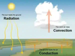
- Radiation: Radiation is the transfer of heat energy through electromagnetic waves. The Sun emits radiant energy, which reaches the Earth’s atmosphere and surface. Some of this energy is absorbed by the atmosphere, while the rest is absorbed by the Earth’s surface. The absorbed energy heats up the atmosphere and surface, contributing to temperature differences and driving weather systems.
- Conduction: Conduction is the transfer of heat energy through direct contact between molecules. Near the Earth’s surface, conduction plays a role in transferring heat from warmer surfaces to cooler ones. For example, during the day, the ground absorbs heat from the Sun and warms up. This warmth is then conducted to the air layer directly above the surface.
- Convection: Convection is the transfer of heat energy through the movement of fluids (liquids or gases). In the atmosphere, convection plays a significant role in redistributing heat vertically. Warm air near the Earth’s surface becomes less dense and rises, carrying heat upward. As it rises, the air cools and eventually sinks back down to the surface, completing a convection cycle. This process is responsible for the formation of clouds, thunderstorms, and other weather phenomena.
- Advection: Advection is the horizontal movement of air, carrying heat energy with it. It occurs when air masses with different temperatures come into contact and exchange heat. For example, warm air moving from the tropics toward the poles (warm advection) or cold air moving from polar regions toward the equator (cold advection) can influence temperature patterns and weather conditions over large areas.
These processes of heat transfer interact with each other and with other factors such as humidity, pressure, and Earth’s rotation to create the complex weather patterns observed in the atmosphere. Understanding these processes is essential for meteorologists to forecast weather accurately and for scientists studying climate dynamics.
Factors affecting Temperature
The factor affecting temperature are as follows:-
1. Latitude:
-
- Latitude refers to the distance of a location from the equator, measured in degrees north or south.
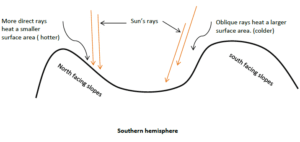
- Areas near the equator receive more direct sunlight throughout the year, leading to higher temperatures. This is because the Sun’s rays are more concentrated near the equator.
- As you move away from the equator towards the poles, the angle at which sunlight hits the Earth’s surface becomes less direct, resulting in lower temperatures.
- Consequently, locations near the equator experience tropical or warm climates, while those closer to the poles have colder climates.
2. Altitude:
-
- Altitude, or elevation, refers to the height of a location above sea level.
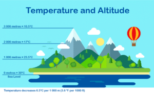
- As altitude increases, atmospheric pressure decreases, and the air becomes less dense. This causes a decrease in temperature with increasing altitude.
- At higher altitudes, the air expands and cools due to the decrease in pressure, leading to cooler temperatures compared to lower elevations.
- For example, mountainous regions often have cooler temperatures than low-lying areas at the same latitude.
3. Distance from the Sea (Continentality):
-
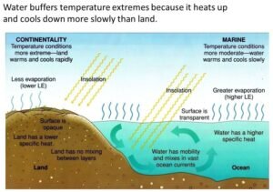
- The distance of a location from large water bodies, such as oceans or seas, affects its temperature variability, a concept known as continentality.
- Coastal areas experience maritime climates characterized by milder temperatures and lower temperature variations throughout the year. This is because water has a higher heat capacity than land, meaning it can absorb and release heat more slowly.
- Inland areas, or continental regions, tend to have more extreme temperature variations, with hotter summers and colder winters, due to the land’s lower heat capacity.
- The moderating effect of water results in coastal areas having a more stable and temperate climate compared to inland regions.
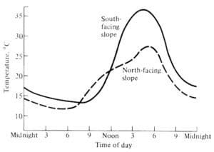
4. Nature of Surface:
-
- The nature of the surface, such as land cover and land use, influences how much heat is absorbed and retained.
- Dark-colored surfaces, such as asphalt and forests, absorb more sunlight and heat up quickly, leading to higher temperatures. This is because dark surfaces have lower albedo, meaning they reflect less sunlight and absorb more.
- Light-colored surfaces, such as snow and sand, reflect more sunlight and heat, resulting in lower temperatures. This is because light surfaces have higher albedo, reflecting more sunlight back into the atmosphere.
- Urban areas with extensive pavement and buildings tend to experience higher temperatures due to the urban heat island effect, where heat is absorbed and emitted by artificial surfaces.
5. Winds:
-
- Wind patterns play a significant role in redistributing heat across the Earth’s surface.
- Winds can transport heat from warmer regions to cooler regions, affecting temperature gradients over large distances.
- For example, warm winds blowing from tropical regions towards higher latitudes can raise temperatures in cooler areas, while cold winds blowing from polar regions can lower temperatures in warmer areas.
- Additionally, local wind patterns, such as sea breezes and mountain breezes, can influence temperature variations in coastal and mountainous regions, respectively.
These factors interact in complex ways to determine the temperature of a particular location, shaping its climate and influencing weather patterns. Understanding these factors is essential for predicting temperature variations and assessing climate variability.
Distribution of Temperature
Horizontal and Vertical Distribution of Temperature is as follows:-
(A). Horizontal Distribution:- Horizontal distribution of temperature refers to how temperatures vary across different regions on Earth’s surface. It is influenced by factors such as latitude, proximity to large bodies of water, wind patterns, and the nature of the surface.
Types of Horizontal Distribution of Temperature are:-
- 1. Longitudinal Distribution (East-West):
- The longitudinal distribution of temperature varies greatly due to the rotation of the Earth and the presence of landmasses and oceans.
- Along the equator, temperatures tend to be consistently warm throughout the year due to direct sunlight.
- Towards the poles, temperatures decrease significantly, with the polar regions experiencing extreme cold due to minimal sunlight angles.
- Landmasses generally experience greater temperature variations compared to oceans due to differences in heat absorption and release.
Isotherms:- It is represented bylines joining places with equal temperature called as isotherms. These are drawn considering temperature at sea level.
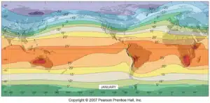
Isotherms at a given latitude should be straight and parallel, but due to presence of oceans and continents with differential specific heat, isotherms bend. During winters, isotherms bend towards poles over oceans and towards equator over continents and vice-a-versa. In southern hemisphere, along temperature latitudes, isotherms are parallel and widely spaced.
- 2. Latitudinal Distribution (North-South):
- The latitudinal distribution of temperature shows a gradual decrease from the equator towards the poles.
- The equatorial regions experience high temperatures throughout the year due to direct sunlight and minimal variation in day length.
- Temperatures decrease towards the poles due to the oblique angle of sunlight and shorter days during certain seasons.
- Seasonal variations are more pronounced in mid-latitude regions, with distinct temperature changes between summer and winter.

Thermal Anomaly:- It is a phenomenon or a condition when place or a region has a different temperature than its latitude. If the temperature is less than the latitude, it is called as negative thermal anomaly and if the temperature is higher than the latitude, it is called as positive thermal anomaly. e.g.:- Death Valley (USA), and Al-Aziziya (Libya).
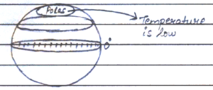
At Poles, temperature is low because of slating sunrays. During winters, temperature is less than 0•C and also experiences long winters. At sub-polar latitudes, temperature is higher than 0•C during summers, but winters are cold and harsh. At temperate latitudes, summer remains moderate and winters record colder temperature i.e. sub-zero. In lower latitudes, temperature is high throughout the year, although hottest or maximum temperature is recorded to the north and south equator. At equator, due to dominance of water and frequent rainfall, temperature is moderated.
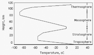
(B). Vertical Distribution:- The vertical distribution of temperature refers to the distribution of temperature in the different layers of the atmosphere at the different latitudes from the earth’s surface. The temperature generally decreases due to the elevation from the surface. The decrease in temperature is different in all places and it is not similar anywhere.
-
- The vertical distribution of temperature varies with altitude in the Earth’s atmosphere and within bodies of water.
- In the atmosphere, temperatures generally decrease with increasing altitude in the troposphere due to the lapse rate.
- In bodies of water, temperature stratification occurs with warmer water near the surface and colder water at greater depths.
- Oceanic thermoclines, layers where temperature changes rapidly with depth, play a significant role in marine ecosystems and climate dynamics.
- Mountainous regions exhibit a significant vertical temperature gradient, with cooler temperatures at higher elevations due to adiabatic cooling and reduced atmospheric pressure.
Understanding the distribution of temperature across longitudinal, latitudinal, and vertical dimensions is crucial for comprehending global climate patterns, weather systems, and ecological processes.
Range of Temperature
The range of temperature refers to the difference between the maximum and minimum temperatures observed within a specific location, region, or timeframe. It provides valuable insights into the variability and fluctuations in temperature over a given period, which have significant implications for various natural processes, human activities, and ecosystems. Here are the following types of range of temperature:
- Diurnal Range: This refers to the variation in temperature within a single day, typically between the daytime maximum and nighttime minimum temperatures. Diurnal temperature ranges can be influenced by factors such as solar radiation, cloud cover, humidity, and wind patterns. In arid regions, where moisture levels are low and skies are clear, diurnal temperature ranges can be particularly wide, with hot daytime temperatures and cool nights.
- Seasonal Range: Seasonal temperature ranges encompass the variations in temperature observed between different seasons (e.g., winter, spring, summer, autumn). These variations are driven by changes in solar insolation, atmospheric circulation patterns, and the tilt of the Earth’s axis. Regions at higher latitudes often experience more pronounced seasonal temperature ranges, with distinct contrasts between cold winters and warm summers.
- Annual Range: The annual temperature range represents the difference between the highest and lowest temperatures recorded over the course of a year. It reflects the combined effects of diurnal and seasonal temperature fluctuations. In equatorial regions and coastal areas, where temperatures remain relatively stable throughout the year due to the moderating influence of oceans or consistent solar radiation, the annual temperature range tends to be smaller compared to continental interiors.
Overall, the range of temperature serves as a fundamental indicator of climate dynamics and variability, providing valuable information for scientific research, policy-making, and community resilience efforts.
Inversion of Temperature
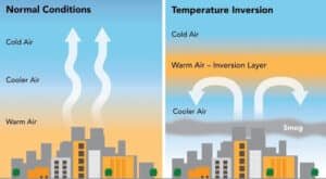
Temperature inversion refers to a meteorological phenomenon where the normal vertical temperature profile of the atmosphere is inverted, meaning that temperature increases with altitude instead of decreasing as it typically does. This reversal of the normal temperature gradient can have significant impacts on weather conditions, air quality, and the dispersion of pollutants.
Practice Question
Q1. Discuss thermal anomaly. Illustrate with few examples.
Q2. Give reasoned account on vertical and horizontal variation in atmospheric temperature.
Class Quiz
Q1. Match the following processes of heat transfer in the atmosphere (List-I) with their descriptions (List-II):-

Codes:
a) A-1, B-2, C-3, D-4
b) A-3, B-4, C-2, D-1
c) A-3, B-4, C-1, D-2
d) A-4, B-3, C-1, D-2
Q2. Diurnal temperature variation refers to:-
a) Temperature variation throughout the day
b) Temperature variation throughout the year
c) Temperature variation along lines of latitude.
d) Temperature variation along lines of longitude
Q3. Match the following factors affecting temperature (List-I) with their descriptions (List -II):

Codes:
a) A-4, B-2, C-1, D-3
b) A-4, B-3, C-1, D-2
c) A-4, B-1, C-3, D-2
d) A-4, B-1, C-2, D-3
Q4. Which of the following term correctly match with their characteristic:-

Select the correct answer from the options given below:-
a) 1 only
b) 2 only
c) Both 1 and 2
d) Neither 1 nor 2
Q5. The process of trapping heat within the Earth’s atmosphere is primarily associated with:-
a) Convection
b) Greenhouse effect
c) Thermal inversion
d) Albedo effect
Q6.Which of the following factors does NOT affect temperature?
a) Latitude
b) Altitude
c) Humidity
d) Longitude
Q7. Match the following temperature ranges (list-I) with their corresponding descriptions (list-II):-

Codes:
a) A-2, B-1, C-4, D-3
b) A-1, B-2, C-4, D-3
c) A-2, B-1, C-3, D-4
d) A-1, B-2, C-4, D-3
This is all about the Geography Class-4 Temperature. In next class, we will discuss about the Temperature Inversion, Types of Inversion, Humidity etc.
| Some Important Links | |
| Geography Class-4 YouTube Short Video |
Click Here |
| Download Geography Class-4 PDF | Click Here |
| If you are satisfied with our website iaspcsprep.com, Please like and share with more people. | |
| Subscribe our YouTube Channel |
Subscribe Now |
| Join our Telegram Channel | Join Now |
| Follow our WhatsApp Channel | Follow Now |
| Join our WhatsApp Group for PDF | Join Now |
| Follow our Facebook Page | Follow Now |
| For any Query and Feedback, Contact Us at – study@iaspcsprep.com. | |

